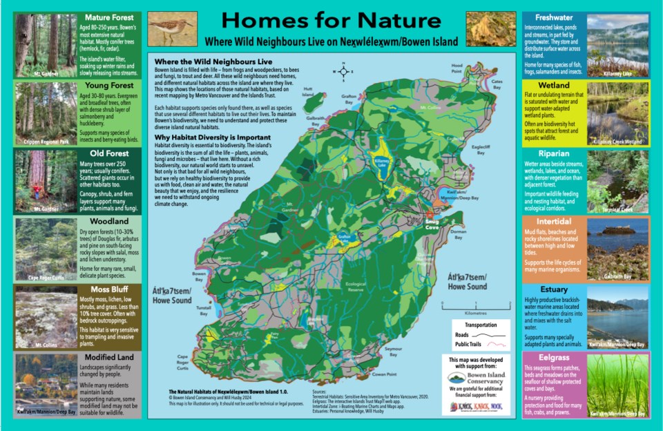
Have you ever wondered where the closest major wetland is to you? Or where to go to experience the island’s oldest forests - remnants of the ancient forests that once clothed Bowen Island?
Now we all have access to a new nature map of Bowen Island, published by the Bowen Island Conservancy, which will help to answer these questions, and many more.
The “Homes for Nature” map is a colourful illustrated guide to our diverse natural habitats, from wetlands and streams, to mossy bluffs and mature forests, and intertidal shores and eelgrass beds. These are the wild neighbourhoods of our island.
Each different habitat type is unique, made up of specific plants, animals and fungi, providing the diversity of life that we enjoy on the island. The map shows where these neighbourhoods are, and is an important and useful resource that will help all of us learn more about habitat diversity, and Bowen’s overall biodiversity.
Bowen has never had a map like “Homes for Nature” before. Now we can all have this resource in our own homes. The Conservancy is distributing the map to all Island schools to engage students with Bowen’s natural world.
As well, it’s available as both a large wall map, and a smaller laminated placemat sized map, and both will be available at the Bowen Island Community School Craft Fair on December 1. Contact the Conservancy if you are interested in larger formats, by writing to [email protected]
The “Homes for Nature” map was produced by Islander and Conservancy member Will Husby, with technical assistance from the Conservancy’s Caring for Nature Initiative team. Funding was provided by a generous grant from the Knick Knack Nook through the Bowen Island Community Foundation.


